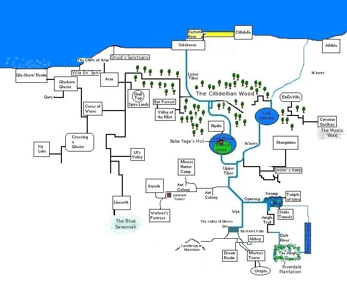
File:Map SC Soloban.jpg
Jump to navigation
Jump to search
Map_SC_Soloban.jpg (712 × 585 pixels, file size: 134 KB, MIME type: image/jpeg)
File history
Click on a date/time to view the file as it appeared at that time.
| Date/Time | Thumbnail | Dimensions | User | Comment | |
|---|---|---|---|---|---|
| current | 21:37, 8 January 2012 |  | 712 × 585 (134 KB) | Soloban (talk | contribs) | * Tweaked area above and around Mysterra Falls |
| 13:36, 8 January 2012 |  | 712 × 585 (133 KB) | Soloban (talk | contribs) | * Added Cill. Wood text | |
| 20:23, 21 November 2011 |  | 712 × 585 (123 KB) | Soloban (talk | contribs) | Added connection between River of Despair and Cymreag (near Isiira) | |
| 18:16, 20 July 2011 |  | 712 × 585 (122 KB) | Soloban (talk | contribs) | Tweaked the area around Cliffs of Aran and added Druid's Sanc. | |
| 13:09, 3 July 2011 |  | 712 × 585 (120 KB) | Soloban (talk | contribs) | ||
| 18:23, 2 July 2011 |  | 712 × 585 (118 KB) | Soloban (talk | contribs) | Added Baba Yaga's Hut | |
| 17:46, 2 July 2011 |  | 712 × 585 (117 KB) | Soloban (talk | contribs) | Added Blue Savannah | |
| 14:04, 11 June 2011 |  | 712 × 585 (112 KB) | Soloban (talk | contribs) | -Added Riverdale Plantation edits not complete by any means! |
You cannot overwrite this file.
File usage
The following 2 pages use this file:
